Is Madrid Ready for the Next Flood?
A data-driven analysis of flood risk, land use exposure, and infrastructure resilience
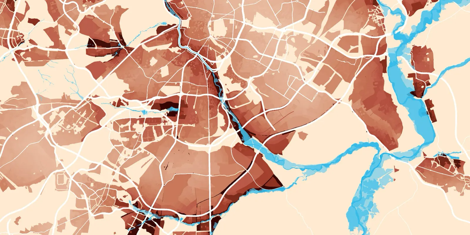
This flood risk analysis is designed to prevent future damage caused by extreme storms in the Comunidad de Madrid. By identifying the most vulnerable urban and infrastructural zones, the aim is to support planners, policymakers, and infrastructure managers in designing smarter land-use strategies and increasing regional resilience to future flood events.
The recent impact of Storm Martinho in Madrid served as a reminder of the destructive potential of unmitigated flood risk. Just in October 2024, the DANA in the Comunidad Valencia left €17 billion in damages in damages and at least 227 lives. With better planning and flood mitigation systems, many of these consequences could have been avoided.
Our cities must be future-proof, designed to absorb the shocks of extreme weather events to keep our inhabitants safe and the city operational. This study identifies Madrid’s most exposed existing and future urban areas, with the goal of guiding targeted mitigation and investment.
Mapping the Risk: Where Is Flooding Most Likely?
Flood prevention infrastructure in Madrid has historically focused on the Manzanares River, which, despite being the most populated area, has the smallest flow among the region’s major rivers. The Manzanares is supported by 32 storm tanks with a total capacity of 1.26 million m³, while only 6 tanks with a total capacity of 162,000 m³ serve the rest of the city of Madrid.
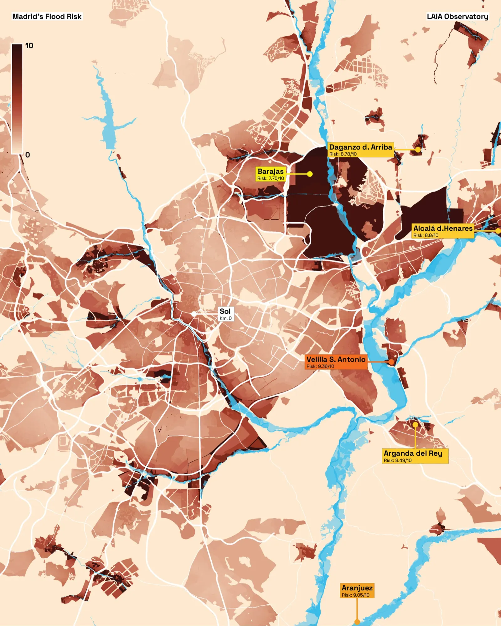
As the city expands — especially eastward toward Jarama basin municipalities — existing and future urban and infrastructure areas face increasing flood risk due to the lack of prevention infrastructure along Madrid’s most water-rich river.
Flood risk in this study is modeled using a weighted score based on:
- Land type (urban, planned, developable, infrastructure.)
- Proximity to floodplains and rivers
- Elevation difference between plots and water bodies
- Forecasted flood behavior
This model identifies land areas consistently affected by past events, confirming their high flood risk through time.
Urban areas most exposed to flooding in Comunidad de Madrid
High Risk (8.75–10): Patones, Velilla de San Antonio, Aranjuez, Alcalá de Henares, Daganzo de Arriba, Aldea del Fresno, Becerril de la Sierra.
Medium Risk (8.5–8.75): Fuenlabrada, Aravaca, Villaviciosa de Odón (Lomas Bosque), Arroyomolinos (Cotorredondo), Arganda del Rey, Alcobendas, Mejorada del Campo, Ajalvir, Camarma de Esteruelas, Pinilla del Valle, Torrelaguna, Cabanillas de la Sierra, Villamanrique del Tajo, Collado Villalba, Alpedrete, Soto del Real.
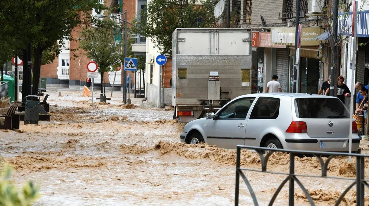
These zones are either directly exposed to river basins or located in topographies that increase runoff concentration, making them especially vulnerable during cloudbursts or prolonged storms.
What Kind of Land is at Risk?
To forecast future vulnerabilities, we categorized flood-exposed land by type:
| Land Type | Flood Risk (>8.5) |
|---|---|
| Urban | 8.28 km² |
| Planned | 0.82 km² |
| Developable | 2.53 km² |
| Infrastructure | 3.78 km² |
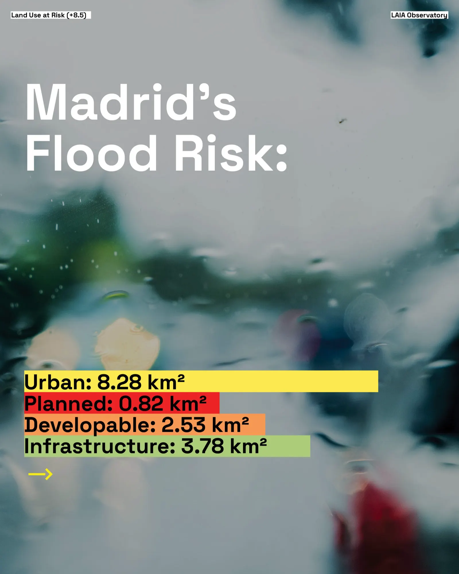
This means not only existing neighborhoods, but also future developments and infrastructure corridors, are in harm’s way. These findings are intended to guide zoning revisions, permitting decisions, and mitigation investments.
Note: Rural land is not considered in this study
Madrid’s Flood Prevention System
Madrid’s flood strategy is among the most sophisticated in Europe. At its core is a network of 65 stormwater detention tanks — 38 of them within the capital, including 32 along the Manzanares stream, providing a total capacity of 1.26 million m³. In contrast, just 6 tanks with a combined capacity of 162,000 m³ serve the rest of the capital.
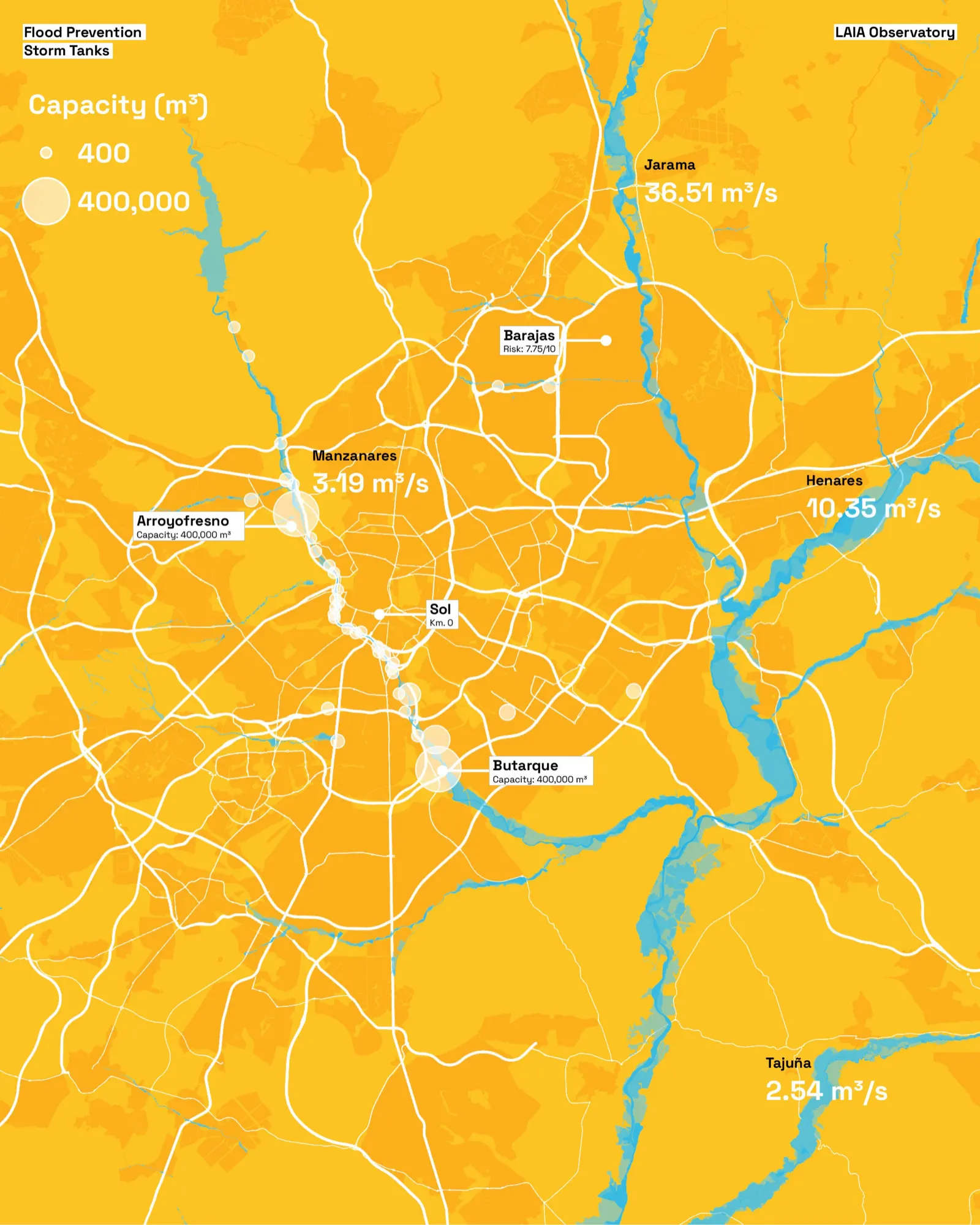
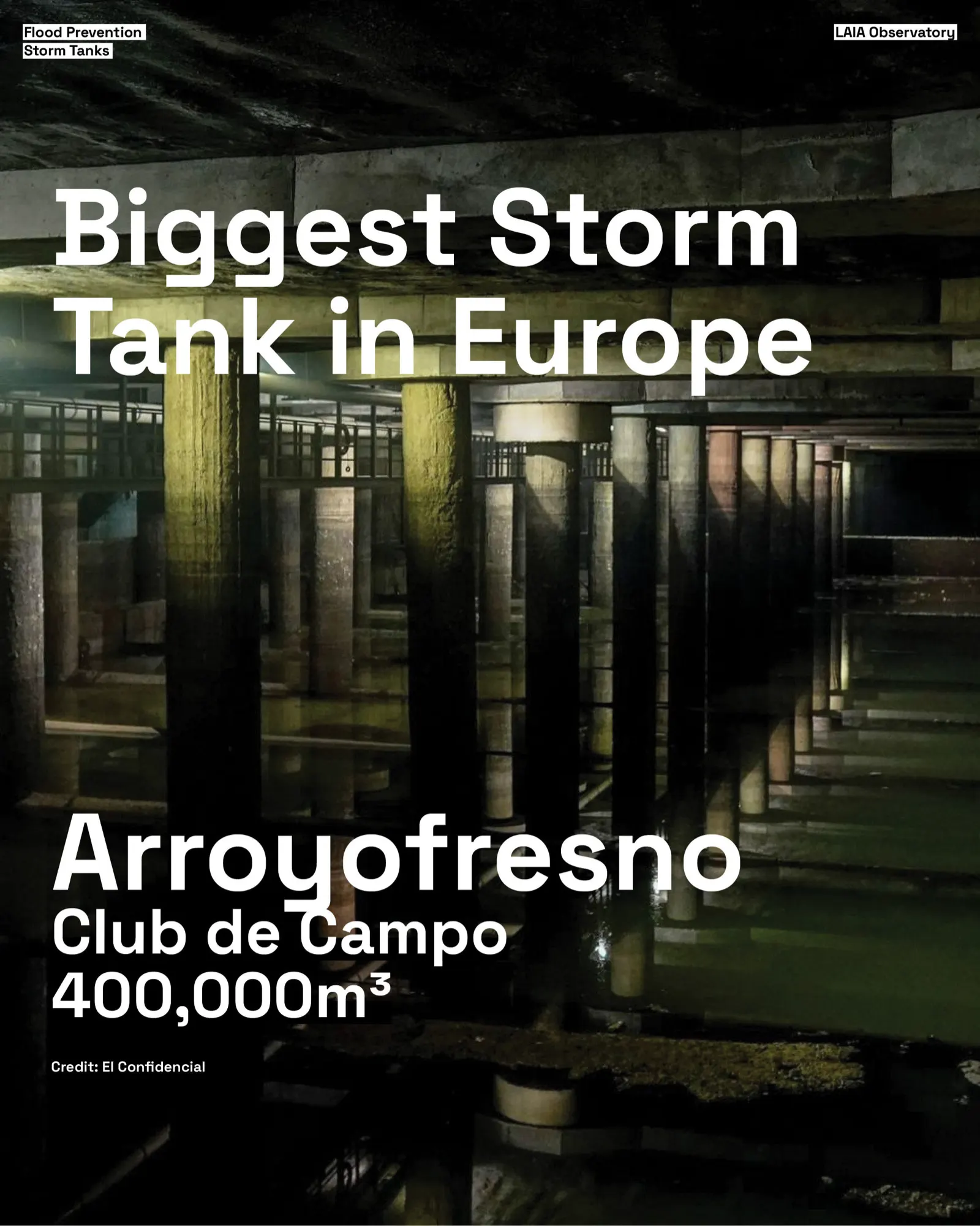
The Arroyofresno and Butarque storm tanks are the largest in Europe, protecting thousands of homes — each with a capacity of 400,000 m³ of water — equivalent to eight times the volume of the lake in El Retiro Park. In comparison, this is the capacity of the biggest storm tanks in Madrid with the biggest in the world, the G-Cans in Tokyo:
| Facility | City | Capacity |
|---|---|---|
| G-Cans | Tokyo | 670,000 m³ |
| Arroyofresno Tank | Madrid | 400,000 m³ |
| Butarque Tank | Madrid | 400,000 m³ |
These tanks function by capturing and temporarily storing the initial surge of rainwater, which is often the most polluted due to debris and contaminants accumulated on urban surfaces. This storage prevents immediate overflows into treatment plants and reduces the risk of polluting the Manzanares River. Once the system stabilizes, the stored water is gradually released for purification, ensuring that only treated water is discharged back into the natural environment.
In tandem with the storm tanks, Madrid has constructed over 34 kilometers of large-diameter collectors to channel rainwater efficiently to treatment facilities. Together, these elements form the backbone of Madrid’s engineered flood prevention strategy, significantly reducing the likelihood of urban flooding.
Complementary Systems
Beyond storm tanks and collectors, the city also employs a broader range of flood mitigation measures, including levees, flood barriers, retention basins, pumping stations, and dikes, depending on the location’s topography, hydrology, and urban density. While not all are visible or equally distributed, they serve to manage and redirect water flow where necessary.
Two additional and complementary systems also contribute to Madrid’s hydrological resilience. First, the Madrid Río project, though primarily an urban regeneration initiative, integrates green infrastructure such as permeable surfaces, re-naturalized riverbanks, and landscaped zones that slow surface runoff and promote ecological flow. Second, upstream reservoirs, including the Santillana Reservoir on the Manzanares, operated by Canal de Isabel II, provide limited flood regulation by modulating river flow. However, as these reservoirs are primarily designed for water supply, their flood prevention role is secondary and limited during high storage periods.
Taken together, Madrid’s flood prevention approach reflects a holistic strategy that blends advanced engineering with environmental design, ensuring that the city is increasingly prepared for the challenges posed by climate change and extreme weather events.
Arroyofresno, an Effective Flood Mitigation
Once a major flood risk area, the Club de Campo de Madrid now benefits from Europe’s largest underground storm tank. Located below a golf course, the 400,000 m³ Arroyofresno tank is a model for multi-functional infrastructure — a key piece of anti-flood infrastructure that protects both urban areas and public assets.
What Counts as Flood Prevention Infrastructure?
- Stormwater Detention Tanks (Storm Tanks)
Underground or surface-level tanks that temporarily store excess rainwater. Released slowly into the sewer system after the storm peak has passed. Often combined with real-time monitoring systems.
2. Retention Basins / Floodplains
Large open areas (sometimes disguised as parks or sports fields) that intentionally flood during storms. Help buffer rivers from overflowing into urban areas. Example: Paris’ Seine has designated floodplains that absorb river overflow.
3. Levees and Floodwalls
Physical barriers built along rivers or coastal zones to hold back rising water levels. Common in places near large water bodies (e.g., New Orleans or the Netherlands).
4. Dams and Reservoirs
Control river flow upstream, holding back excess water during storms and releasing it gradually. Key for both urban and rural flood prevention, especially in hilly terrains. May include emergency spillways for extreme events.
5. Green Infrastructure
These are nature-based solutions that absorb or slow water runoff such as permeable pavements, green roofs, rain gardens / bioswales, urban trees and vegetation. A great example is Madrid Río project (tunnelled the M-30 to restore floodplain above).
6. Improved Sewer and Drainage Networks
Often the first line of defense, but many cities have outdated or undersized systems. Can be upgraded with separate sewer systems for stormwater vs wastewater. Sometimes includes smart valves or gates to redirect flow based on pressure levels.
7. Smart Monitoring & Early Warning Systems
Sensors, radar, weather forecasting, and AI-based alert systems. Allow real-time water level tracking in rivers and drainage points. Can trigger automated pumping, alerts to residents, or reroute flows dynamically.
8. Subsurface Tunnels & Underground Rivers
Large-scale, high-budget interventions to re-route floodwaters below cities. Examples includes Tokyo’s G-Cans Project — massive underground floodwater diversion system.
9. Levees, Dikes, and Flood Barriers
Structures that physically block floodwaters from entering urban areas — essential near major rivers or coastlines. Often reinforced with riprap, concrete, or natural vegetation for added stability.
10. Pumping Stations
Especially critical in low-lying areas or below-river-level basins (think New Orleans or parts of Amsterdam). Can evacuate water from streets, basements, or retention zones during heavy rainfall events.
Conclusion
As climate change accelerates and extreme weather becomes more frequent, cities like Madrid must shift from reactive recovery to proactive prevention. This analysis reveals the uneven distribution of flood protection infrastructure across the region and highlights key vulnerabilities in both current and planned urban areas — especially around the Jarama River.
With data-driven risk mapping and forward-looking infrastructure planning, Madrid has the opportunity to lead by example in urban flood resilience. The tools and insights are here to drive bold action.
We believe data must lead policy. That’s why LAIA’s Observatory is in collaboration with MWCC — connecting data-driven research with action in the face of urban and climate challenges.
If you’re involved in urban planning, infrastructure design, climate resilience, or public policy — let’s connect. Let’s ensure Madrid is not just reactive but prepared.
Explore our work at https://www.laia.org/
For partnerships, data access, or insights: contact@laia.org
Bibliography
- “Cinco meses de la dana”, El Pais, 2025: https://elpais.com/opinion/2025-03-29/cinco-meses-de-la-dana.html
- “Storm Tanks: Defending our Rivers”, Canal de Isabel II: https://www.canaldeisabelsegunda.es/en/-/tanques-de-tormentas-protectores-de-los-rios
- “The World’s Largest Storm Water Tank Is Hidden Under A Golf Course In Madrid”, Euro Weekly, 2023: https://euroweeklynews.com/2023/09/04/largest-storm-tank-world-under-golf-course-madrid/
- “Stormwater Management in Spain”, Water World, 2015: https://www.waterworld.com/wastewater-treatment/article/16201719/stormwater-management-in-spain
Data Sources
- Storm Tanks: “Tanques de Tormentas”, Portal de datos abiertos del Ayuntamiento de Madrid.
- Flood zones with frequent flooding: “Sistema Nacional de Cartografía de Zonas Inundables”, Miteco
- Flows: “Anuario de Aforos”, CEDEX
- Water: “Ministerio para la Transición Ecológica y el Reto Demográfico”
- Dams and Reservoirs: “Inventario de Presas y Embalses”, Ministerio para la Transición Ecológica y el Reto Demográfico.
- Type of Land: “Mapa de Clasificación y Calificación Urbanística de la Comunidad de Madrid”, Datos Abiertos, Comunidad de Madrid
Originally published on Medium on 16 April 2025: read the original.